Coupled Natural-Human System Modeling (CNH)
Project Description
A CNH system consists of natural and human sub-systems, each sub-system includes a number of components, and all component can be respectively analyzed using various models. Most of these models are related to each other through land cover/land use, with land cover/use data serving as both input and output. Currently, in the CNH research community, there is no standardized protocol or software that can be used to easily integrate all models for the CNH study purpose. Our objective is to develop a land use/land cover model to couple the sub-models derived from this study, and once empirically validated, the model can then be used to simulate future scenarios.
Work Summary
This study area of this project is the Lower Mississippi River Basin (LMRB). My work in this project includes two parts: estimating land subsidence rates and modeling population dynamics.
High subsidence rates, along with eustatic sea-level change, sediment accumulation and shoreline erosion have led to widespread land loss and the deterioration of ecosystem health around the Lower Mississippi River Basin (LMRB). A proper evaluation of the spatial pattern of subsidence rates in the LMRB is the key to understanding the mechanisms of the submergence, estimating its potential impacts on land loss and the long-term sustainability of the region. Based on the subsidence rate data derived from benchmark surveys from 1922 to 1995, we constructed a subsidence rate surface for the region through the empirical Bayesian kriging (EBK) interpolation method.
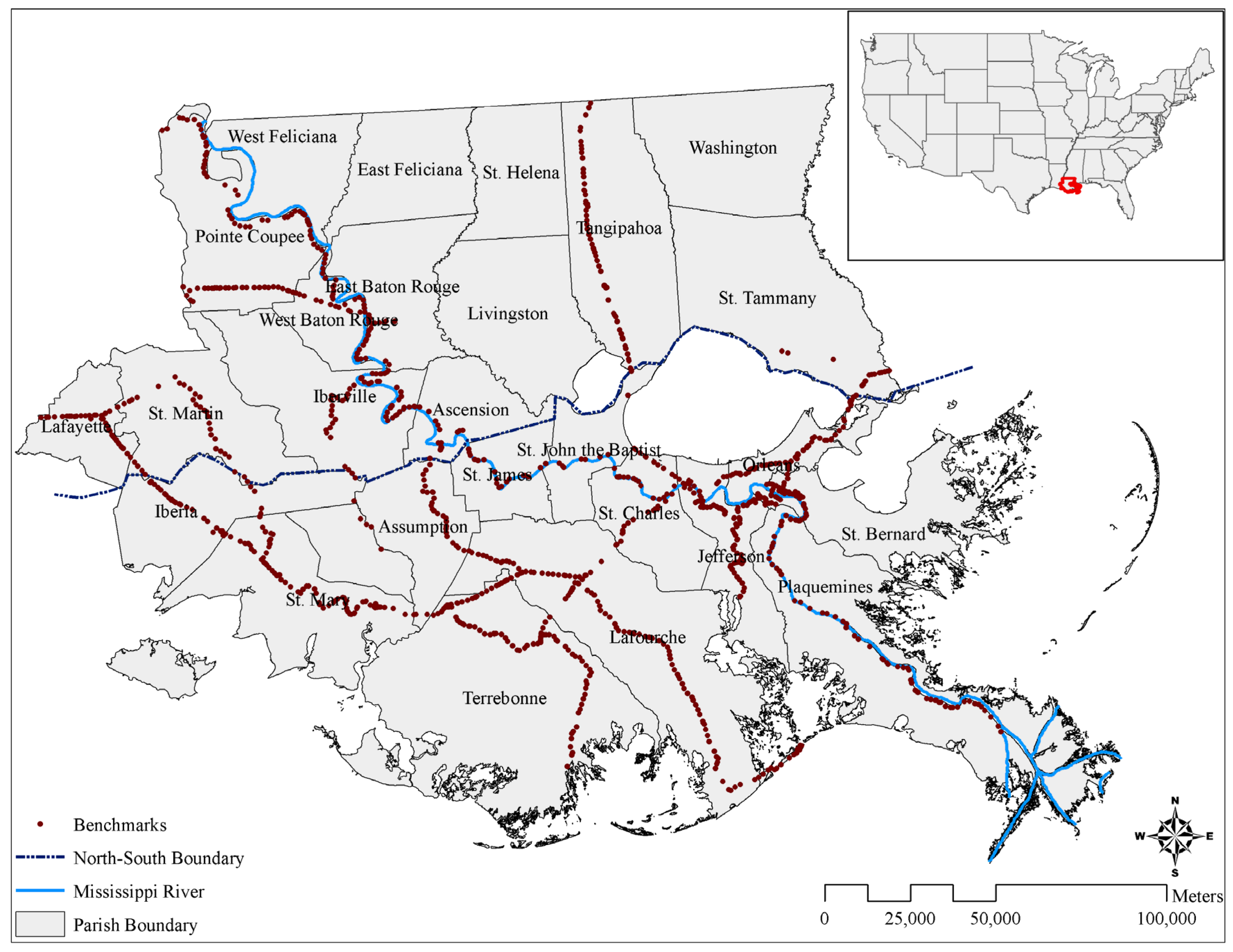
Figure 1. The study area, Lower Mississippi River Basin (LMRB), and the locations of benchmarks.
The second part is modeling population dynamics in response to the frequent coastal hazards, such as flooding, hurricanes and storm surges. The summary and manuscript of this part is under preparation.
Outcomes
The results show that the subsidence rates in the region ranged from 1.7 to 29 mm/year, with an average rate of 9.4 mm/year. Subsidence rates increased from north to south as the outcome of both regional geophysical conditions and anthropogenic activities. Four areas of high subsidence rates were found, and they are located in Orleans, Jefferson, Terrebonne and Plaquemines parishes. A projection of future landscape loss using the interpolated subsidence rates reveals that areas below zero elevation in the LMRB will increase from 3.86% in 2004 to 19.79% in 2030 and 30.88% in 2050. This translates to a growing increase of areas that are vulnerable to land loss from 44.3 km2/year to 240.7 km2/year from 2011 to 2050. Under the same scenario, Lafourche, Plaquemines and Terrebonne parishes will experience serious loss of wetlands, whereas Orleans and Jefferson parishes will lose significant developed land, and Lafourche parish will endure severe loss of agriculture land.
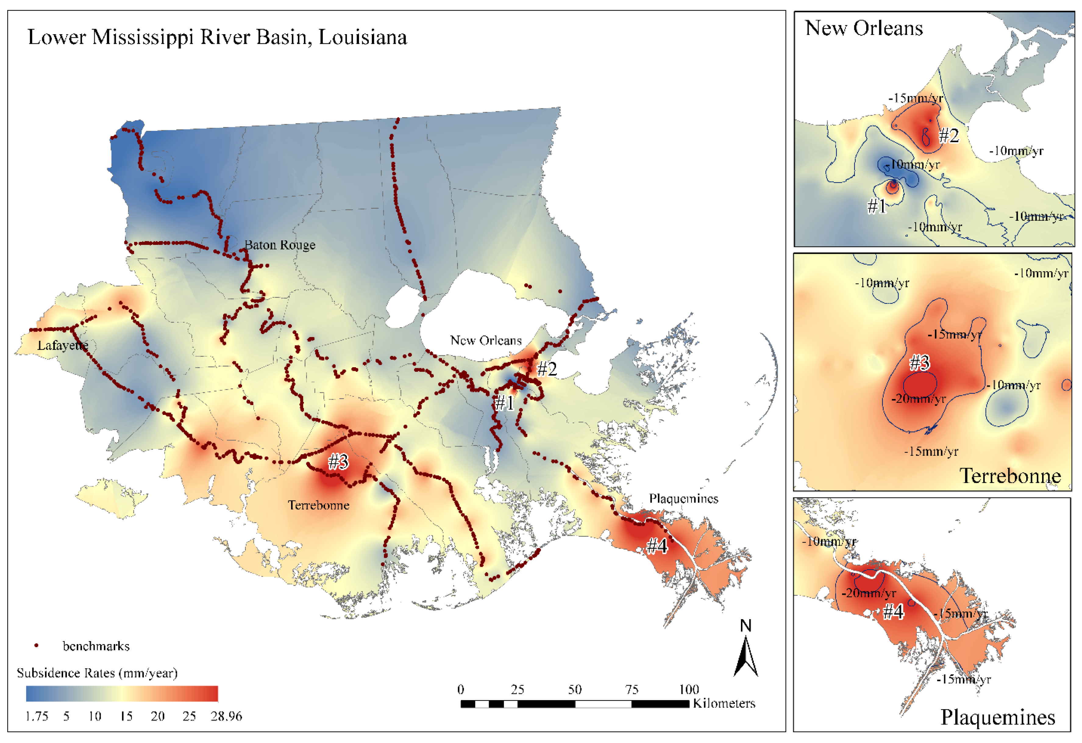
Figure 2. The interpolated subsidence rates in the LMRB
References
Cai, H., Lam, N.S.N., Zou, L., and Qiang, Y. Modeling the dynamics of community resilience to coastal hazards using a Bayesian network. (Accepted).
Qiang, Y., Lam, N.S.N., Cai, H., and Zou, L. 2017. Changes in exposure to flood hazards in the United States. Annals of the American Association of Geographers, 107(6):1-19. [Access]
Zou, L., Kent, J., Lam, N. S. N., Cai, H., Qiang, Y., & Li K. (2015). Evaluating land subsidence rates and their implications for land loss in the Lower Mississippi River Basin, Water 8(1): doi:10.3390/w8010010. [Access]