Community Resilience Assessment (CRA)
Project Description
Community resilience describes the ability of a community to 'bounce back' after a disaster event. Coastal communities around the world are facing mulitiple threats from natural hazards, including storm surges, hurricanes, and floods. Therefore, it is very important to enhance community resilience and realize coastal sustainability. However, community resilience is difficult to evaluate, due to the inconsistency in variable selection and indexing methods, as well as the lack of validation methods. The objectives of this study are to examine: (1) developing models to evaluate community resilience; (2) understanding how resilience varies across space and socioeconomic status; and (3) developing management tools to help public enhance disaster resilience.
Work Summary
Our research group has developed practical tool, the Resilience Inference Measurement (RIM) model, to estimate community resilience. The RIM model was orignally designed to assess community resilience to coastal hazards in 52 counties along the Gulf of Mexico. Currently, the RIM model has been successfully applied in community resilience to multiple types of natural hazards at different spatial scales and regions. For example, Cai et al. 2016 employ RIM model to estimate the block-group level community resilience to coastal hazards in the Lower Mississippi River Basin; Mihunov utlized RIM model to evaluate the county-level community resilience to drought in the South-Central United States.
The RIM model defines resilience as three dimensions and two relationships (figure 1). The three dimensions are the exposure to disasters, damage sustained, and the recovery process. Vulnerability indicates the relationship between exposure and damage, while adaptability represents the relationship between damage and recovery.
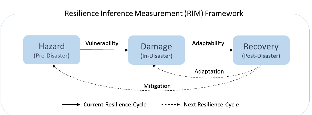
Figure 1. Framework of the Resilience Inference Measurement (RIM) model (modified from Cai et al. 2016)
Outcomes
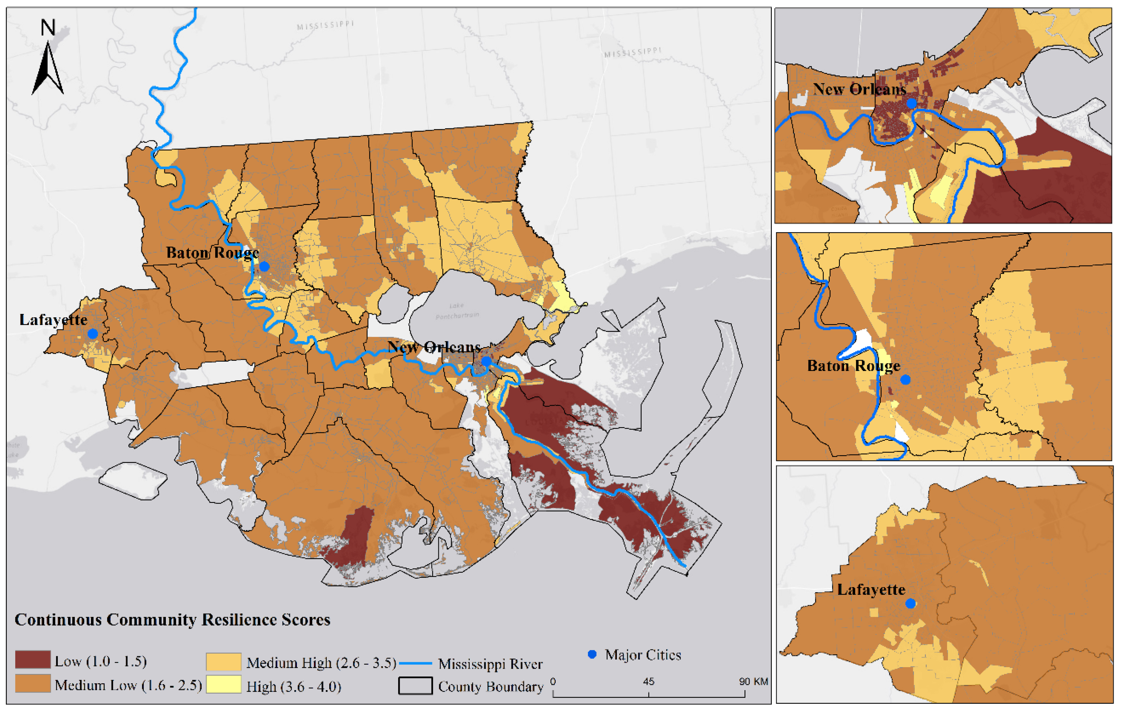
Figure 2. Community resilience to coastal hazards in the Lower Mississippi River Basin at block-group level. (Cai et al. 2016)
References
Zou, L., Lam, N.S.N., Cai, H., and Qiang, Y. Mining social media for improved understanding of disaster resilience (Accepted)
Mihunov, V., Lam, N.S.N., Zou, L., Rohli, R.V., Bushra, N., Reams, M.A., and Argote, J.E. 2017. Community resilience to drought hazard in South-central United States. Annals of the American Association of Geographers. 1-17. [Access]
Cai, H., Lam, N.S.N., Zou, L., Qiang, Y., and Li, K. 2016. Assessing community resilience to coastal hazards in the Lower Mississippi River Delta. Water, 8(2):46. DOI: 10.3390/w8020046. [Access]
Rohli, R.V., Bushra, N., Lam, N.S.N., Zou, L., Mihunov, V., Reams, M.A., and Argote, J. E. 2016. Drought indices as drought predictors in the south-central USA. Natural Hazards 1-16. DOI: 10.1007/s11069-016-2376-z. [Access]
Li, K., Lam, N.S.N., Qiang, Y., Zou, L., and Cai, H. 2015. A cyber-infrastructure for community resilience assessment and visualization. Cartography and Geographic Information Science. 42(sup1):34-39. DOI: 10.1080/15230406.2015.1060113. [Access]