|
||
|
|
 |
|
|
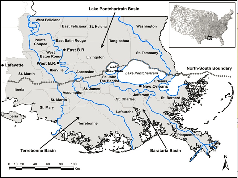
Study Area The study area (Figure 1), broadly recognized as the Lower Mississippi River Basin (LMRB), is located in southeastern Louisiana and extends from the parishes (i.e. counties) north of Lake Pontchartrain to the coast (Fig. 1a), and was selected as a result of combining both the natural boundaries (watersheds) and political boundaries (parishes). This region encompasses 26 Southeastern Louisiana parishes. The selected study area combines both natural boundaries (Mississippi River and Atchafalaya River watersheds) and political boundaries (parishes). The study area is partitioned in two main regions to the north and south of Lake Pontchartrain and includes two major metropolitan areas (New Orleans and Baton Rouge). The region has diverse natural and human landscapes and is strongly influenced by infrastructure dedicated to oil exploration and energy production
|
|||||
|
This website is based upon work supported by the National Science Foundation (NSF) under Grant Number (NSF Grant Number: 1212112). Any opinions, findings, and conclusions or recommendations expressed in this website do not necessarily reflect the views of the agency. Comments on the content: cnh@lsu.edu Created in RSGIS Lab, LSU Provide Website Feedback Accessibility Privacy Statement |
|||||